Category Archives: News

News and events around the Lake Champlain Valley of northern New York and Vermont and southern Quebec

Threatened Northern Sunfish Discovered in Lake Champlain Tributary

Threatened Northern Sunfish Discovered in Clinton County
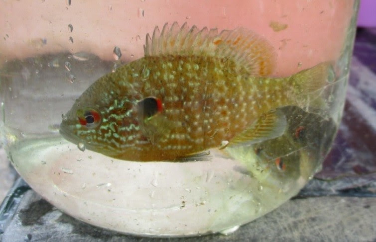
 

Threatened Northern Sunfish Discovered in Lake Champlain Tributary- Great Chazy River in the village of Champlain, Clinton County, New York.

                           Northern Sunfish

The New York State Department of Environmental Conservation’s Rare Fish Unit has confirmed the presence of northern sunfish in the Great Chazy River in the village of Champlain, Clinton County, New York.

In early September Biologist Doug Carlson and technician Eric Maxwell identified nearly a dozen of the threatened fish species in the river.

“We are ecstatic for this discovery and it adds to the unique species in the Great Chazy River that showcase its diversity and fishing appeal,” said Carlson.

Also known as the longear sunfish, the northern sunfish is a small, thin, deep-bodied fish that averages three to four inches in length. It is sometimes a colorful fish with an olive to rusty-brown back, bright orange belly, and blue-green bars on the side of the head. The northern sunfish has short, round pectoral fins and an upward-slanting gill cover flap that has a white and red flexible edge.  It is often mistaken for a pumpkinseed sunfish.

The northern sunfish is a threatened species in New York State and it has suffered immense losses in Western New York.  Biologists have speculated that several factors are involved, including interactions with non-native fish like green sunfish and round goby. The population of this recent discovery in the Chazy appears robust and quite localized.


Other Articles on the Fish of Lake Champlain:    


Lake Champlain Basin Program Seeks to Develop High Resolution Land Use / Land Cover Map

Lake Champlain Basin Program Seeks to Develop High Resolution Land Use / Land Cover Map For The Lake Champlain Basin

Lake Champlain Basin Program Seeks to Develop High Resolution Land Use/Land Cover Map For The Lake Champlain BasinThe Lake Champlain Basin Program (LCBP) is pleased to announce a Request for Proposals (RFP) for services to develop a detailed land use / land cover map for the U.S. portion of the Lake Champlain Basin. Up to $150,000 is available for this project.

This project will provide an up-to-date map of 16 land cover types, including urban lands, forests, and agricultural lands within the Lake Champlain Basin. Accurate land use/land cover data are a critical tool for resource managers and planners. Scientists analyze this information to determine how development and other uses of the landscape affect habitat and the amount and quality of runoff to local water bodies. Existing datasets are based on satellite imagery that is more than ten years old; the new data will be developed using the most current imagery available.

This project will to help achieve the goals of the Lake Champlain long-term management plan Opportunities for Action: An Evolving Plan for the Future of the Lake Champlain Basin. It is supported with funds awarded to the New England Interstate Water Pollution Control Commission by the US Environmental Protection Agency (US EPA) in support of the Lake Champlain Basin Program. LCBP anticipates granting one award from this RFP.

To obtain a copy of the Request for Proposals, visit www.lcbp.org/grants or contact the Lake Champlain Basin Program office at (802) 372-3213 or (800) 468-5227. Proposals are due in the LCBP office by electronic submission on November 1, 2016 at 4:30 p.m.

Canada Addresses Flooding Issues in Lake Champlain – Richelieu River Basin

Canada Addresses Flooding Issues in Lake Champlain – Richelieu River Basin

Flooding issues in Lake Champlain – Richelieu River basin in 2011. Credit: Vermont.gov.

Flood damage around Lake Champlain in 2011. Credit: Vermont.gov.

The Honorable Stéphane Dion, Minister of Foreign Affairs, announced that the Government of Canada is taking action to address the risks associated with recurrent floods in the Lake Champlain – Richelieu River basin, located in southern Quebec, northeastern New York State and northwestern Vermont.

After careful review of the recommendations made by the International Joint Commission (IJC) in its July 2013 report, Plan of Study for the Identification of Measures to Mitigate Flooding and the Impacts of Flooding of Lake Champlain and Richelieu River, Canada and the United States have asked the IJC to proceed with its implementation and explore more fully the causes, impacts, risks and potential solutions to the flooding issues in the Lake Champlain – Richelieu River basin.

The IJC has extensive and unique experience in handling the full range of regional transboundary water issues, including its high-quality work on a previous request related to flooding issues in the Lake Champlain R ichelieu River basin. The International Lake Champlain-Richelieu River Technical Working Group presented to the IJC its final report and technical reports on November 30, 2015.

‘The Government of Canada welcomes the opportunity to collaborate with our Quebec and United States colleagues, as well as with the IJC, to address long-standing risks associated with flooding in the Lake Champlain-Richelieu River basin. We count on their continued cooperation as we further assess flooding and mitigation measures in the Lake Champlain-Richelieu River water basin. This work will improve the physical, social and economic security of residents on both sides of the border.’ – Stéphane Dion, Minister of Foreign Affairs

Recognizing that changing conditions in boundary water basins have significant implications for economic, social and environmental interests along the border, the Government of Canada allocated up to $19.5 million over five years in the 2016 Budget to enable Canada to study water quality, quantity and flooding issues in four Canada-U.S. boundary basins. Of this, $7.53 million will be allocated to the IJC to explore potential flood plain management solutions and a range of moderate structural and non-structural flood prevention and mitigation measures in the Lake Champlain-Richelieu River basin.


‘Reducing the risks and effects of flooding will have a real and positive impact on the lives of residents in the Lake Champlain-Richelieu River basin. The work of the IJC, in collaboration with federal, provincial and local efforts, will contribute to ensure a secure and sustainable future for the people in this region, particularly with respect to water quality.’ – Denis Paradis, Member of Parliament for Brome-Missisquoi

Facts About the IJC and Lake Champlain–Richelieu River Basin Flooding

  • Established by the Boundary Waters Treaty of 1909, the IJC is a binational organization mandated to prevent and resolve disputes, primarily those concerning water quantity and quality, along the Canada-U.S. border.
  • Canada’s participation in the IJC is the responsibility of Global Affairs Canada. The Canadian share of the IJC’s annual budget ranges between $6 and $8 million and is allocated through the federal government’s annual budget and appropriations process.
  • The IJC’s 2013 report, Plan of Study for the Identification of Measures to Mitigate Flooding and the Impacts of Flooding of Lake Champlain and Richelieu River, will serve as the basis for ongoing work.
  • The Richelieu River flood in spring 2011 was arguably the worst overland inundation in southern Quebec since Confederation and Quebec’s worst natural disaster since the Saguenay flood in 1996. In at least 20 municipalities, waters inundated streets up to a kilometre from the riverbanks. Water did not just drain into the Richelieu River, southerly winds also pushed metre-high waves into the river from Lake Champlain. With overpowering force, water surged north at volumes as much as five times greater than the Richelieu River’s average year-round flow.

Online Fishing Regulations Tool – Fishing Regs at Your Fingertips

Online Fishing Regulations Tool – Fishing Regs at Your Fingertips

Fishing regulations are important tools for managing Vermont’s diverse fisheries and meeting the varied desires of the angling public. The Vermont Department of Fish & Wildlife has developed an  Online Fishing Regulations Tool that uses current technologies to make finding regulation information quick and simple.

Online Fishing Regulations Tool - Fishing Regs at Your Fingertips

Online Fishing Regulations Tool


This internet-based tool offers multiple functions, including:

  • Interactive Map System – lets users select any waterbody in the state and have instantaneous access to fishing regulations specific to that body of water.
  • Current Location Feature – the map also works in coordination with the Global Positioning System (GPS) in many mobile devices, allowing users to view fisheries regulations for their current location.
  • Lookup Tables – allows users to view regulations by selecting a waterbody, town, or county from a comprehensive lookup list.

Regardless of the pathway, the final result is a simple and clear list of fisheries regulations for each waterbody in Vermont.

To get the Vermont Online Fishing Regulations Tool,  Click Here.

The Online Fishing Regulation Tool is just the first of several steps the Vermont Department of Fish & Wildlife is taking to help anglers more easily sort through and understand fishing regulations. They are also planning to develop a mobile fishing regulations application that will work in areas without internet access, and add more fishing-related information to the mapping platform to expand its uses beyond providing fisheries regulations alone.


Other Lake Champlain Fishing Articles:

September is Vermont’s River Cleanup Month – And How You Can Help

September is Vermont’s River Cleanup Month

September is Vermont's River Cleanup Month and Watersheds United Vermont invites interested volunteers to get involved.

Missisquoi River Basin Association volunteers at a cleanup. Photo Credit: Lindsey Wight

When Vermonters think of September, they picture the last days spent swimming in our lakes and rivers, or the first cool nights that signal the start of fall. However, for many Vermonters, September also signifies the perfect time of year to put on some work gloves and join friends and neighbors in hauling tires, refrigerators and shopping carts from our rivers and streams. September is Vermont’s River Cleanup Month and Watersheds United Vermont invites interested volunteers to get involved.

For years, local watershed groups and other volunteers in Vermont have organized river cleanups to remove trash that has accumulated in our waterways. Trash in rivers not only creates an eyesore for paddlers and swimmers, but it also negatively impacts riparian wildlife and adds pollutants to our waters. In 2014, the Vermont legislature, recognizing the importance of river cleanups, designated September as Vermont’s official River Cleanup Month. Lyn Munno, director of Watersheds United Vermont (WUV), the organization coordinating the statewide River Cleanup Month effort, says: “September is a great time to clean our rivers- water levels are usually not too high and the temperature is still mild.”


This September’s river cleanups are already being planned by local groups across the state. In 2015, Vermont River Cleanup Month participants hauled 16,000 pounds of trash from rivers and shorelines at 30 cleanup events.

Mary Russ, Director of the White River Partnership and a seasoned river cleanup leader says: “The WRP organizes cleanup events at White River access sites as a way to make the river cleaner and safer for recreational use. Each fall, dozens of volunteers remove hundreds of pounds of trash from the river, from drink containers to tires to everything in between.”


Vermonters can participate in River Cleanup Month in a couple of ways. Contact your local watershed group to see if you can help with a river cleanup in your watershed, or organize your own cleanup with neighbors, club members, classmates, or co-workers. To register an existing cleanup or to access resources on running a successful river cleanup, check out WUV’s River Cleanup website (http://www.watershedsunitedvt.org/vtrivercleanup).


WUV is collaborating on Vermont’s River Cleanup Month with two other organizations that have decades of combined river cleanup experience: Connecticut River Watershed Council’s Source to Sea program, which is running its 20th annual cleanup for the Connecticut River watershed, and American Rivers, which has run its National River Cleanup since 1991.


Watersheds United Vermont (WUV) is a state-wide network of local groups dedicated to improving the health of their home watersheds. WUV’s mission is to empower community-based watershed groups throughout the state to protect and restore Vermont’s waters. Please contact WUV at watershedsunited@gmail.com or 802-585-3569 for information or suggestions about Vermont River Cleanup Month. Make sure to tag any River Cleanup Month social media photos or posts with #vtrivercleanup.